
Ukrainian
Topographic
Map
Features
We obtain the geodata for the map from OSM servers. Updates are released
approximately once a month; there are no resources for daily map
rendering (help). The map has detailed tourist
coverage, thanks to millions of OpenStreetMap users. Every day, the map
file increases by an average of 400 KB, which is about 200 km of roads
and 300 points of interest. I want to note that, unfortunately, for
motorists, this map has significantly less detailed coverage and address
information. From a tourist point of view, the map is quite valuable.
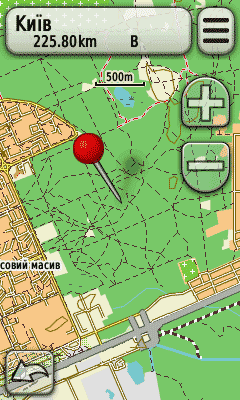
Features of this map:
① Ukrainian language of the map (there are also Russian and English
languages, switched together with the language of the navigator)
② Topographic coloring and landmarks, such as clearings, parking lots,
springs, wells, stops.
③ Relief and shaded relief for easier navigation in the mountains
④ The map includes elevation contours, which can be turned off via the
menu
⑤ Route planning on all types of roads and trails (emphasis on cycling
routes)
⑥ Changing the detail of the map and drawing styles at different
scales
⑦ Highlighted cycling routes at scales up to 300m
⑧ All tourist places in Ukraine have quite detailed coverage.
Changelog
v1.2
Added relief and its shadow. Numerous improvements. March 2025
v1.09
Changed colors and style of the map. Numerous improvements.
v1.08
Increased database of points of interest in Polissya. Display of
clearings in forest massifs.
v1.07
The map has been filled with more than 4000 points of interest,
including reserves of all types, natural monuments of all types,
arboretums, tracts, caves, etc. Clear distinction in the style of
displaying dirt roads and trails.
v1.06
The map has been merged again with the contour map. Contours are
adaptive; in the mountains, contours are every 5m up to a height of 450m
and then every 10m. In Polissya, contours are every 2m. On the coast,
every 5m. In the rest of the country, contours are every 10m. Color
correction.
v1.05
The map is divided into two files, the topo map itself and a contour
file every 20m. This was done for compatibility with etrex navigators.
Color correction.
v1.04
Added clearings with a white dashed line. Cycling routes are highlighted
for better display at scales from 2km to 300m.
v1.03
Generating elevation contours and including them in the map file as an
additional map, which can be turned off from the navigator menu
(settings - map - map information - "UkraineTopoMap - Contours")
Editing the display of swamps, fields, gardens, bushes, parks, forests,
and plantations.
v1.02
First public version. Distributed among acquaintances and friends.
Licenses and Rights
By using the map, you fully accept the
License Agreement for using the map.
We obtain the data for this map from OpenStreetMap servers under the
terms of the
ODbL
license.
Data for the elevation map is obtained from the NASA Jet Propulsion
Laboratory under the terms of source attribution.
Garmin is a registered trademark of Garmin Ltd.
Installing the map for an inexperienced user may cost them
the operability of the navigator. Each map, before publication, is
uploaded to an Oregon 450 navigator, and only after testing is it
uploaded to the site. However, we are not responsible for any technical
or software damage due to the use of our map.
Our website uses cookies, which make it more convenient for each user.
By visiting the pages of the site, you agree to our
privacy policy.
Support the Project
You can help the project stay afloat by
purchasing a copy of the map.
You can also help for free. Since the content of the map lies on the
shoulders of OpenStreetMap users, by registering on the
openstreetmap.org website and editing the map of
Ukraine, you are helping to expand the coverage of our country and make
this map better and more complete.
Contacts
Contact us regarding map design issues at -
admin@salviadorium.pp.ua
Instructions on how to install the map are described in detail
here.